| Partridge River Trip Kesagami Lake to Moosonee July 1992 |
|
This little known river is a pleasure to canoe. It offers a great deal of
variety ranging from lake travel, runnable white water, quiet meandering
stretches, and then tops it all off with a short stint on James Bay. There
are very few portages for a trip of this length. We logged 6 or 7, the first
being between Kesagami lake and Partridge lake, The others around
waterfalls, ledges and chutes. Quite a few liftovers and some dragging were
required in the upper stretches where the river is narrow and also
extensively in the Blackbear Island area.
The entire trip took us 11 days. Of those 11 days we spent 2 extra days on
Kesagami Lake doing some fishing, and took 2 rest days when it was pouring
rain. We paddled for 7 days - some of which were long paddles (8-10 hrs per
day). We recommend a minimum of 7 days for this trip.
Access:
1. Float plane from Cochrane to Kesagami Lake (method used by us).
2. Float plane from Cochrane to Partridge Lake
(avoid the quarter/half mile portage between Kesagami and Partridge Lakes)
3. From Cochrane by car to Upper Kesagami Lake. Upper Kesagami is directly
accessible from hwy 652 about an hours drive north of Cochrane. From there,
a series of lakes and narrow rivers will take you to Kesagami Lake.
(add approximately 4 to 5 days to your trip) NOTE: we used this access point
when we paddled the Kesagami River a few years later – for information on
this portion of the trip please refer to my trip report on the
Kesagami River
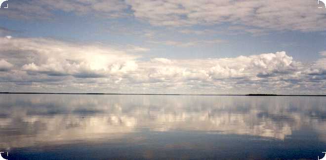
Kesagami Lake
Kesagami Lake is approximately 10 km by 22 km large (we were surprised by
the actual size) and generally quite shallow. There is a commercial
hunting/fishing lodge located on the south east side of the lake.
We spent our first night at the lodge. The people were friendly, the food
was good, and it was a wonderful opportunity to get to know a bit more about
the area and listen to the'fish' stories of other guests. One fisherman
had caught a 22 lb pike the previous day.
Kesagami Lake is classified as a wilderness provincial park so you can camp
anywhere on the lake. Our experience however, was that there were few good
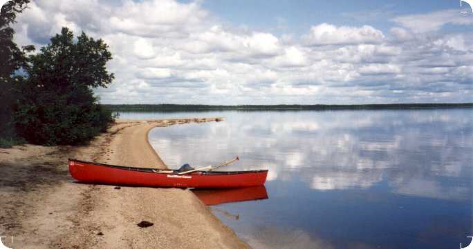
campsites on the lake. The sandy beach at the narrows where Newman Bay comes
into Lake Kesagami, as well as some of the beaches on the west side of Big
Island looked as if they could be potential campsites. We camped on the far
western tip of the peninsula above Opimiskau Bay. This spot has an
established fire pit and was actually marked as a park campsite. There was a
lovely sand spit on the very point of the peninsula that provided a
relatively 'bug free' place to sit as well as a panoramic view of the
lake. Seagulls, loons and ducks also like the sandy spit. Some seagull type
birds were nesting there.
The weather changes quickly on this lake. We camped/fished there for three
days. It rained a little every day, and the rain clouds often seemed to come
with high winds. Exercise caution if attempting to cross a wide span of this
lake.
If you like fishing, plan to spend a few extra days here. It was the best
fishing that we had on the entire trip, and the best fishing I (personally)
have had anywhere. It is one of the few lakes in Ontario that offers trophy
pike fishing. Our catch was usually pike or walleye. The pike we caught
ranged from 3 to 6 lb, the walleye were smaller. We released all fish except
those that we planned to eat.
Caribou are reputed to be numerous on this Lake. We saw one in the distance
about 4km south of our campsite, and also fresh caribou tracks appeared
around our campsite while we were out fishing one day.
There was a strong south wind on the day we left the lodge. Our route across
the lake took us from the lodge (situated just north of Newman Bay), along
the south shore trying to stay in the lee of the wind. We then cut across to
Big Island to avoid crossing the bay which lies south of the island, and
went around the north shore of the island, again to avoid the wind. We had
to paddle into the wind coming back down the west side of the island to
it's southerly tip, and then cut across to an easterly point jutting out
from the peninsula. We then followed the edge of the peninsula until we
reached the campsite on the point. We camped on the point for two full days
(3 nights).
 |
On the day we left the campsite, the weather was very calm so we cut across
Opimiskau Bay in a north westerly direction that would take us almost
directly to the portage trail. Depending on the winds, a shorter crossing of
the bay is possible if you go almost directly west and then work your way up
the shore.
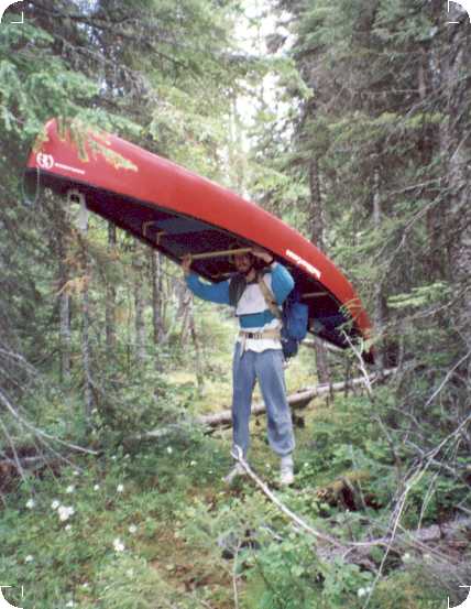
The portage trail to Partridge Lake is located on the left side of a sandy beach. It takes you to the south east corner of Partridge Lake. The trail is not marked in any way, but once you get close enough to it, there is an obvious path going into the woods. It is approximately a quarter of a mile long over a rough path. Expect lots of bugs and fallen logs over the path. |
Partridge Lake/Upper River
From the portage trail to the beginning of the river is a short paddle along
one side of Partridge Lake. You will pass a fishing/hunting cabin just
before you reach the top of the river. Rumour has it that the owner is not
particularly friendly, and we were told to simply ignore him. We did not see
anyone at the cabin - he may have been in one of the two boats that we saw
further down the lake. These boats were (with the exception of bush planes)
the last we saw of people until the Moose River.
| Welcome to the river! The upper portion of the river was barely passable
with the water levels that we had. Higher water (earlier in the season)
would have been much preferable here. We did a lot of dragging over blow
downs and rocky/rapid type areas. The river is VERY narrow. We had a 16’
canoe. There were many places where an eddy turn would have been impossible
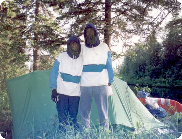
due to the narrow nature of the river. If you're here in bug season (we
were), there is no escape from the bugs.
Niska and Richards Lakes offer a break from the river (bugs) at this point.
The long quiet meandering south point of Niska Lake looked as if it would
have great potential for wildlife watching. We saw a beaver, and various
waterfowl including a loon sitting on her eggs. The trees in this area are primarily feeble looking black spruce. We had some trouble finding a tree into which to hoist our pack (for bear purposes). |
 |
The next days travel is a lot of work. At least it was with the water level
we had. We had the notes of a previous tripper who had done the river in
spring run off, it took him three hours to do a portion of the river that
took us six. The day was especially tough due to rain that moved in at about
11:00 am (just about the time we set off) and lasted until about 7:00 in the
evening. The bugs on the narrow river were very bad with both of us wearing
bug nets for most of the day, gloves (bug proof) would be good, socks (bug
proof) would be good. If any part of you is revealed, the
bugs will get you!
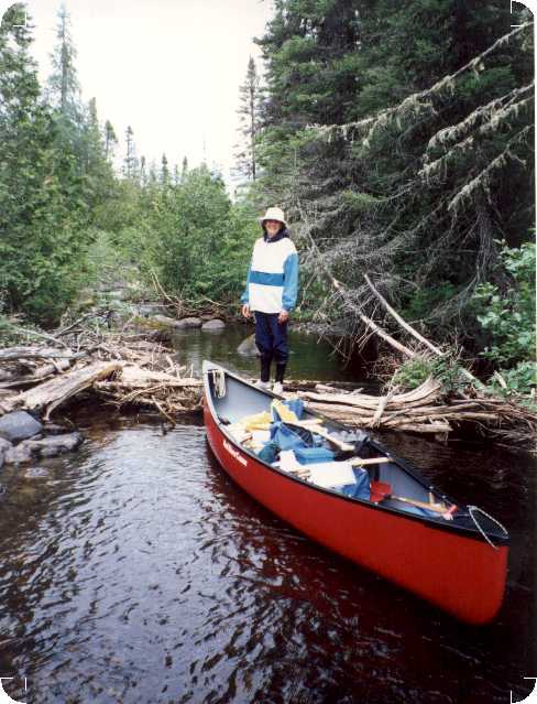
This portion of the river has many blow downs. Some have been cleared out,
some cut through. We cut through some that stood in the way of what would
otherwise have been an obviously good run. Many we simply took a run at and
tried to cross without having to leave the canoe and drag. Usually, we had
to get out and drag anyway. The current is swift here. Between blow downs
there are small rapids that could have been run in higher water and although
we could run some, we ended up dragging over the majority of them.
Higher water would have made the rapids easier to run, but a faster current
could have made the blow downs more dangerous. The river twists and turns.
Often the blow down obstacle is just around a sharp bend in the river, or
in/after a set of rapids. With the current as we had it, this was no
problem, but with a swifter current you could be within the blow down almost
before you could react.
Count on one day of rough going to get through this section. As mentioned
previously, it took us six hours. We camped at one of the first obvious
campsites we could see... high on rock cliffs above a chute. It was a bit of
a hike getting our gear up, but it was the nicest campsite we had seen that
day. If we had gone on, there was another nice campsite about an hour down
the river, and others not far after. Most of these were on rocks, above
falls, chutes or on portages.
The only type of tree in this area was (still) stunted black spruce. We
found it very difficult to haul our packs into one of these trees , and some
creativity was necessary to get our packs off the ground.
Rapids
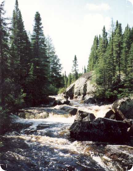 |
The chute above which we camped seemed to mark a change in the river. We camped above the chute for two more days due to almost solid rain and cold (with frost). We're still not sure whether the nature of the river changed, or whether the rain changed the river for us. The rain had increased the water level by approximately eight to ten inches. From this point on, there were progressively fewer blow downs, and the rapids became more and more runnable. Within an hour of leaving the campsite, we found we did not have to do any dragging at all. |
There is no better way to describe this portion of the river than to say
that if you want runnable white water, this is the place to be. We paddled
for approximately nine hours that day, and it's safe to say that five or
six of those were through some degree of white water or swifts.
The river presents one set of rapids, then meanders a bit with a nice
current but no rapids, presents another set of rapids, meanders... and so
on. It gets wider as you go along and soon you're far enough away from
shore to get away from bugs. The rapids get progressively more difficult as
you near the Kanatotik rapids. There is a lovely 3 to 4 km set of
rapids/swifts about an hour above the Kanatotik rapids that were indicated
by only one hatch mark on our top map.
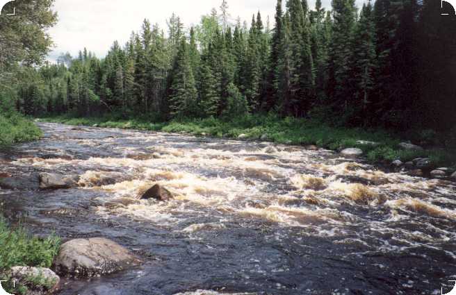
By the time we reached the Kanatotik rapids, they seemed to be a natural
(although technically more difficult) progression from what we had already
run. The river here is shallow and bouldery with class 2 to 3 rapids. We
would run a set of rapids, pause in an eddy, bail out the canoe, scout ahead
from the canoe and off we'd go. This scenario was repeated over and over.
Here we benefited from the rain that had stopped us for a couple of days.
Judging from the vegetation at the side of the river, the water level here
appeared to be a foot higher than it had been prior to the rain. We were
able to run all of these rapids. If necessary, portaging, dragging or lining
are possible along the shore.
There were numerous camping possibilities in this portion of the river.
Often by rapids, chutes or on portages around them. Although there were no
particularly good campsites right in the Kanatotik rapids, camping there
would enable you to spend more time 'playing' in the rapids. We ran
through them so quickly that we were disappointed to be done.
After the Kanatotik rapids there are small rapids and swifts that are all
runnable. Nice campsites begin to get a bit scarce and we camped on a
gravely bank, an hour or so after the rapids. We were hoping that by staying
out of the woods we could avoid the worst of the bugs - but they found us.
The worst bugs yet! The next morning we broke camp without breakfast, just
to get onto the river and away from the bugs. In a way we were fortunate we
got on the river so early, it provided us with the opportunity to see both a
bear and a moose out for their early morning rounds.
The river continues to offer small rapids, waterfalls, and chutes at less
frequent intervals from here to Bear Island. The waterfalls we portaged
(look out in particular for one 10 foot waterfall hidden within a set of
rapids). Later we encountered a chute over where we portaged our gear and
then ran. All in all a very entertaining section of the river.
Blackbear Island
As you near Blackbear Island, you see portions of an old burn area. Quite
desolate.
At Blackbear Island the river splits into a very distinct left and right
branch. The top of the right branch is a 10 to 15 foot falls. There is a
campsite on the rocks far above the falls but it's quite a hike from the
river. If you want to stay at this campsite, you are more or less committed
to taking the right branch of the river. Taking the right branch means that
you will have to do a half mile portage around the falls. Although we were
told about this portage, we walked this area and did not see an obvious
portage trail.
Partly to avoid the portage, and partly to explore a part of the river about
which we had no information, we chose the left branch. To get to the left
branch, you can either run the rapids above the falls and ferry across to
the left side of the river (again could be strongly influenced by water
levels), or you can take the river to the far left (it splits a bit here)
and if necessary, drag, line, carry canoe until you feel safe in the left
branch. The river is quite wide, if you try to run the rapids and ferry to
the left and fail... you could go over the falls!
On the left branch, after the obvious small rapids that are visible from the
split in the river, there is another small set just around the bend that we
managed to 'squeak' through (but may have to be dragged over). Below this
second set there is a channel through the island that connects the right and
left branch. One could avoid the portage and use the channel to get to the
right branch. We stayed on the left branch.
From this point on, count on at least a couple of hours of lining, dragging
and lift overs, with some runnable rapids in between. The top map shows one
hatch mark here. This is totally unrepresentative of what to expect. From
the notes of a previous tripper, the right branch appears to be about the
same... a lot of work.
There are potential campsites at various places on the rocks at the side of
the river. These are possibly the best campsites you'll see for the
remainder of the trip. Avoid the tendency to push through the 'tough stuff’
before you find a campsite. By the time you're through, there won't be any
campsites that compare. Certainly if you're near the end of a day, camp in
this area.
Both sides of the river at the top part of the island are a burn area.
Again, very desolate. Not much growing here but blueberries. Desolate, but
very interesting in its own way.
After a couple of hours of lining, dragging and lift overs, you are more or
less through with rapids for the rest of the river.
Lower River
I'm going to refer to the section from below the rapids & falls around Blackbear Island, to the split where the river branches to the left for the
first time above the delta as the lower portion of the river. Count on at
least one good solid day of paddling to do this portion. It took us longer.
We didn't camp in the rocky area at the south portion of Bear Island. We
elected to continue on our way. It was raining (again). After the 'hard
work' portion, the left branch continues around the island as a fairly
narrow, fairly slow flowing river. Trees branch over it in a cathedral
effect. Quite pretty in all. We paddled through this portion for at least
another hour before the two branches joined again.
Once the branches join after Blackbear Island, the river is quite wide with
a steady current. The current isn't very noticeable until you stop paddling
and realize that you are still drifting along at a good pace. For this
portion of the river we only had a 1:250,000 top map. It was very
misleading. There were a lot of meanders in the river and it took a good
deal longer to cover any distance than we estimated.
The notes of the previous tripper indicated a very swift current in this
area that enabled him to cover 30 miles (maybe km?) in one afternoon. With
the water conditions that we encountered, it took much longer.
We paddled for another couple of hours that day, looking for a good
campsite. There are not many in this portion of the river. We passed three
islands of various sizes, and camped on the northern tip of the third. We
seemed to have camped on some sort of beaver throughway - loud tail
splashing late at night indicated their displeasure to find us there.
Still referring to the notes of a previous tripper, we felt that having done
about three hours of this portion of the river the day before, we should be
within a half day paddle of James Bay. Wrong. We had a full days' paddle
ahead of us even to reach the split in the river. Again, the top map was
misleading, what looked like 10 km was obviously much more by the time you
count in the meanders of the river.
All in all it could have been a very pleasant portion of the river to
paddle. Steady current, a few shallow swifts... but we were impatient to get
to James Bay, and were disappointed at our progress. We saw lots of
waterfowl in this portion of the river. We also scared up what we think was
a bear judging from the loud 'crashing' through the woods as it ran away.
 |
After about seven hours of paddling, we finally came to the split in the river. Slightly confused by how long it took us to do this part of the river, and not sure how much longer it would take to get to the Bay, we started looking for campsites. Again, not many camping choices here. We passed a cleared out area with a table and frames for canvas tents. We stopped there but felt too much as if we were trespassing (also the bugs were terrible!). We camped a little further down the river in another small cleared out area. There was garbage at the site and lots of bugs, but we didn't think we'd find anything better. |
If you are near the end of the day, try
camping somewhere around the split in the river, perhaps at the split
itself. The closer to James Bay you get, the fewer camping possibilities
there are. Do not expect to be able to camp on the shores of the Bay. To do
so would involve dragging the canoe through reeds to find ground that may
(or may not) be solid ground, and may (or may not) be influenced by tides.
All in all, not an appealing option.
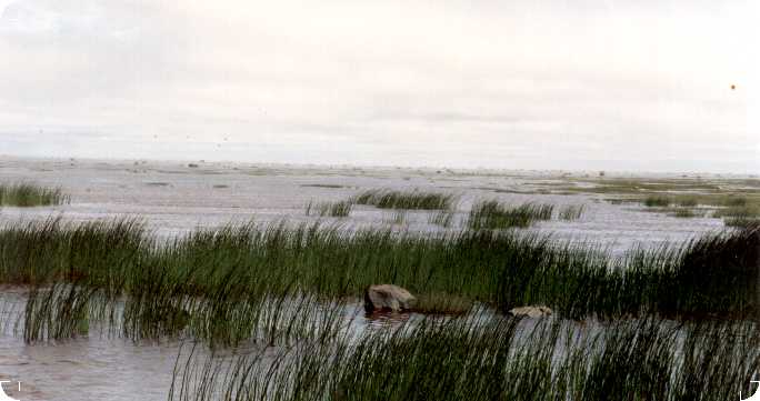
Marsh/James Bay/Moose River
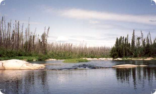
Very soon after the split, the nature of the river begins to change. More
and more willows crowd the banks. You see less and less trees. The current
is still quite swift. The river begins to split as it enters the delta. We
chose the far right channel whenever we had a choice. Our rationale was that
the Little Partridge River would come into this branch and give us more
water than the other branches.
Within an hour of leaving our campsite, the willows on the banks were giving
way to marsh grasses. Soon, marsh was all we could see ahead. The river
continued to split, getting shallower with each split. We picked our way
from channel to channel, looking for enough water to paddle through,
dragging the canoe where necessary. If the Little Partridge ever did come
in, we missed it. It may have been in the form of one of many marshes that
joined with the marsh we were in. It was on odd feeling not knowing how long
the marsh would continue before it led to James Bay. After our difficulty in
judging distances the previous day, we were beginning to fear that we might
be in for a long day in this marsh wasteland.
We had a strong wind from the north so at least we were always sure of the
direction we should be going. The trees in the distance began to take on the
look of a mirage.
About two hours after leaving our campsite, about an hour or so after
entering the marsh, the grasses parted before us. Huge boulders stood out on
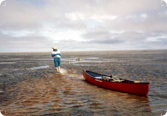
the horizon. This was James Bay! It was low tide. As far as the eye could
see were shallow mud flats, with boulders strewn about. The strong north
wind blew a mist in the air. On the far, far distant shores beyond the
delta, trees seemed to float on air. It was something that words cannot
adequately describe.
We had planned to camp on the shore of the Bay to study the tides (we had no
tide tables - suggestion - get tide tables). We realized very quickly that
there was no possibility of camping here. We began to wade, pulling our
canoe, looking for deeper water. Fortunately the 'mud' flats were firm
enough to make wading possible. A small but very distinct line of water
rippled towards shore. The tide was just beginning to come in. Suffice to
say that the tidal flats of James Bay should only be attempted at moderate
to high tide. We dragged the canoe out until the water level (assisted by
the incoming tide) made it possible to paddle.
Now is a good time to mention that the Ministry of Natural Resources DOES
NOT recommend paddling across any portion of James Bay. They have good
reason. After our trip (while waiting for the train at Tidewater Provincial
Park), we heard stories of swamped canoes and lost boats (and lives) on the
Bay. It may be possible to be picked up by float plane or freighter canoe
from the mouth of the river.
For us, it was very tough going across the Bay. We had a strong north wind
and an incoming tide that we had to paddle across. There were peninsulas of
reeds at times reaching far out from shore. Going through them was
difficult, so we had to go out to get around them. We seldom encountered
water any deeper than the length of our paddles. This would be a very
difficult paddle if the wind was against you, and dangerous if the wind and
tide conspire to push you out into the Bay.
If we did this portion of the trip again, with the help of tide tables, we
would try to enter the marsh an hour or so before the highest point of the
tide. This would provide higher water than we had in the marsh, as well as
enough water to paddle the mud flats. You would (hopefully) have enough time
to get through the marsh and across the tidal flats to the Moose River
before the tide left you parked in mud. Of course, this means you’d be
facing the Moose River with an outgoing tide – not a pleasant thought. One
could always take a break for a few hours until the tide came back in and
ride the incoming tide up the Moose.
One source suggested that we catch the outgoing tide through the marsh and
ride it out into the Bay, and then ride the incomming tide back in and up
the Moose River, but if you get top maps of this area, you’ll see that the
tidal flats go far out from shore. Trying to follow the tide out to find
enough water to paddle could be dangerous if the winds (unpredictable at the
best of times) turn against you when you’re far from shore.
There’s no clear answer to the best approach here.
If you are interested in seeing James Bay, but as little of it as possible,
one possibility for shortening the Bay portion of the trip would be to take
left channels through the marsh and thus end up at the west side of the
delta (closer to the Moose River). One could take this a step further and
consider the possibility of taking the left fork of the Partridge where it
split above our last campsite. We have no idea what either of these options
would be like through the marsh/delta area.
As is, it took us between two and three hours to reach Amold Point and the
mouth of the Moose River. When you turn the point and look south to the
Moose, you are very aware of the great width of the river.
We felt our trip was over when we reached this point. It's wasn't .
There’s still a long paddle ahead. As soon as the river got a little
narrower, we cut across and paddled up the right hand shore (Moosonee lies
on the right hand shore). With a strong north wind behind us and an incoming
tide, we were able to sail the distance in about 3 hours. An outgoing tide
combined with a south wind could make this a miserable paddle.
Tidewater Provincial Park
Tidewater lies between Moosonee and Moose Factory. It's a provincial park
with all related luxuries such as running water (cold only) (no showers
though). It's been cleared of a lot of brush so the bugs weren't nearly as
bad as they were on the river. The camping fee (1992) was $ 12.25 per site
per night. Hotel accommodation is usually available in Moosonee but much
more expensive.
The Little Bear Train from Moosonee to Cochrane runs two days a week
(Wednesday and Friday) and unlike the Polar Bear Express (which runs daily)
will carry freight (canoes).
Sky Bicevskis
Topo Maps (1:50,000)
42 I/8 Kesagami Lake
42 I/9 Glaister Lake
42 I/16 Marberg Creek
42 I/15 Meengan Creek
42 P/2 Bushy Island,
42 P/1 Thyret Lake
42 P/8 Ship Sands Island
42 P/7 Moosonee