| Kesagami River Trip Upper Kesagami Lake to Moosonee July 1995 |
This river had been teasing us ever since Rob first read about the Kesagami
in Canoeing Ontario Rivers by Ron Reid and Janet Grand.
The river can be accessed in two ways: one by float plane from Cochrane to
Kesagami Lake; the other by car up hwy 652 to Upper Kesagami Lake. We
decided that if we were going to paddle this river, we would start at Upper
Kesagami Lake - we expected this to add 3 to 4 days to the trip (it actually
added 5).
Searching for information on the river was frustrating. Our usual source of
information, the Ministry of Natural Resources tried to discourage us, and
there were few documented trips from other sources. The best source turned
out to be Canoeing Ontario's Rivers. It had a surprisingly accurate review
of the river from Kesagami Lake to James Bay. The upper portion of the river
(above Kesagami Lake) was still an unknown. Just by chance, we met the owner of Kesagami
Lodge (a fly-in fishing lodge on Kesagami Lake) at the Toronto Sportmen's
Show. He gave us the name of a man from Michigan who had paddled a number of
rivers in that area, including the Kesagami. We contacted him and he
supplied us with some pretty good information on the upper portion.
July 1995, found us putting in from highway 652 (calling it a highway is
generous - it's really a gravel road) to Upper Kesagami Lake after a long
hot dry spell that had broken temperature records and resulted in a total
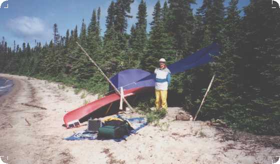
fire ban in the area. With three weeks worth of food and gear, we set out.
1) Upper Kesagami Lake to Kesagami Lake (days
1 - 5)
The first half day or so took us from small lake to small lake separated by
stretches of a narrow river choked with blow downs. There were no rapids
here, and the greatest challenge was getting over the blow downs. Obviously
some hunters or fishermen had come this far from the highway because in many
places the older blow downs had been sawn through. Our first camp was on the
first lake of any reasonable size after Upper Kesagami Lake. It was a short
paddle (perhaps two or three hours) from our access point. We camped on a
small sand spit reaching out into this unnamed lake. This is a very nice
campsite, and we were glad that we stopped here. This is the last nice
campsite for a couple of days
We awoke the next morning to a fine drizzle blown in by a brisk north wind.
The temperature was 6 degrees Celsius. It appeared that with our arrival,
the hot dry spell had passed.
The river was still narrow when it left the lake, but there were
progressively fewer and fewer blow downs. The river meandered through semi
marsh. Willows leaned in from the banks, and occasionally we paddled through
wide areas of marshland. In a few places we could see some sort of raised
platforms that must have been used for hunting in the fall, and some
flagging tape here and there. At this point it's the only sign of man.
There's a great deal of wildlife in this area. All sorts of waterfowl fled
feigning injury to divert us from their young, and the river banks are
covered in prints - moose, bear and various smaller animals.
Intriguing at first, the constant meandering grew tiresome after the first
few hours. Fortunately the bugs weren't bad. If it had been a bad season for
bugs, this could have been 'hell' as the river was so narrow that there
would be no escape from them.
After a long day of paddling, waiting for the meanders to end and hoping for
a good campsite, we more or less hacked a place for the tent from the
willows on the bank. A dusk, the bugs came out with a fury, and the
occasional drizzle turned into rain.
The next day was more or less of the same. More meanders, more intermittent
rain, even a few rays of sunshine as the river slowly widened. After a long
paddle through a marsh, we came into an unnamed lake that we called 'Fossil
Lake'. It was one of the larger lakes we'd come across so far. It was a
shallow lake and some of the beaches were almost completely covered in
fossils. We wanted to collect a few, but the prospect of some long portages
ahead, and thinking that there would surely be other opportunities, we
didn't. A decision that we later regretted. There were no other good fossil
collecting opportunities for the rest of the trip.
Soaked and chilled by the sometimes heavy downpours, we looked for a camp
site. Any part of us not covered by Goretex was completely wet. My Goretex
jacket kept half of me marvelously dry (good stuff that!) but I've decided
that Goretex pants are also a must. Rob, who had them, was almost completely
dry.
We saw a sandy beach with a grassy area behind it which looked like a lovely
campsite. As we got closer we could see a cabin just up from the beach.
Although it appeared to be deserted (probably used for fly-in hunting later
in the season) we didn't want to camp near it. Across the lake from the
cabin was a rocky, fossily beach with a sandy spot big enough for a tent. It
was a reasonable camping spot, and we decided that, weather permitting, we
would take a rest day here.
The next day dawned cloudy and cool. It wasn't raining (yet), but not a
worthwhile rest day. After leaving the lake, the river changed character.
Instead of willows and marsh the ubiquitous black spruce come right to the
shore. The river still meandered, but the meanders were fewer and farther
between. It was a real treat to be able to see more than a few hundred yards
ahead.
The day warmed up, and we had both patches of sunshine and tremendous
downpours accompanied by thunder and lightning. Once, caught in the middle
of a small lake, it rained so hard that the water appeared to boil around
us. The next cloud burst caught us back on the river, in the first little
set rapids we'd come across. This time the thunder is so intense that we
held onto the shrubs by the shore and hoped that the overhead spruce would
catch the lightning. Soaked (again) we found a pleasant campsite in a
clearing under the spruce. The rain passed, and the sun came out in time for
us to string up a line and attempt to dry some of our gear.
The next day we started on a stretch of river that had numerous small rapids
and swifts. They might have been fun to paddle with another 4 to 6 inches of
water. As is, there was a lot of scraping and dragging to get through them.
The rapids passed, the river widened and deepened. We could see a little
more marsh along the shores and after a long paddle, we came into Kesagami
Lake.
2) Kesagami Lake Day 5 - 7
Kesagami Lake is a huge shallow lake. It is approximately 20 km long, and
ranges in width from 1 km in the narrow southern end, to 10 km in the main
body of the lake. The narrow southern end of the lake is called Newnham Bay.
This bay is over 10 km long but usually quite narrow (1-3 km wide). Once out
on the main body of the lake, you can barely see the other shore. We've been
told that it's only 20 to 30 feet deep in most spots.
The fishing here is fabulous. There's a fly in fishing lodge on the lake,
and if one explored the possibility, one could possibly have supplies flown
in here. You could also begin the trip at this lake by flying into it (on a
previous trip we flew into this lake and paddled the Partridge River which
is accessible by portaging to a nearby lake). Kesagami Lake and the Kesagami
River from the lake to James Bay are classified as a wilderness provincial
park.
Our plan was to spend a day or so on the lake - maybe camp near the lodge
and go in for a beer or maybe 'buy' a nice hot shower. The lodge was still
about 10 km away from where we entered the lake, and we'd already paddled a
full day so we searched for a campsite on the lake.
Finding a campsite was difficult. We crisscrossed Newnham Bay many times
looking for a good spot. There was something that actually looked like a
designated campsite on one shore, but due to all the rain we'd had, it was
very muddy with a little stream running through it. We eventually found a
sandy spit where a small stream came in. We set up camp to the sound of
thunder. Rob went to clean a pike that he'd caught in the lake, but we both
had to dive into the tent for cover as a huge thunder, rain and wind storm
passed through. It lasted for perhaps half an hour, and was probably the
most severe storm that I've ever experienced. Most of our tent pegs were
torn from the ground and we sat on the corners of the tent to keep them
down. The driving wind forced the rain under the tent and when it was over,
there were a couple of inches of water on the ground sheet under the tent.
Rob, our camera man, caught some amazing footage of this storm on video from
within the tent.
Dawn the next day brought a strong south wind, so with visions of beer and
hot showers we set up a sail and powered by the wind, sailed north to the
main body of the lake. It was a day of disappointments. We knew of only one
camping spot near the lodge - right on the narrows where Newnham Bay met the
main body of the lake. Even from a distance we could see that a float plane
was parked by the spot. We paddled by to see a couple of tents set up.
Camping there was obviously not a possibility.
Plan 2. We would paddle to the lodge and at least stop by for a beer and
still hoping - hot shower. It was a little after noon, and with the lodge
guests all out fishing, the lodge was quite deserted except for an employee
on the dock who wasn't particularly friendly. We asked him about possible
camping sites - he told us he didn't think we were allowed to camp anywhere
on the lake (although the Ministry of Natural Resources had told us
otherwise). Assuming we had flown in and had a plane moored somewhere, he
asked us if we had a landing permit. On discovering that we had paddled down
from the road, and were heading for the lower portion of the Kesagami River,
he expressed disbelief and the usual attitude of 'are you sure you want to
do that?'. Disappointed, and somewhat subdued we set off again and still
powered by the strong wind, sailed off across the huge expanse of lake
towards one of the few other campsites we knew of, a sandy beach on the
north shore.
It seemed like only a couple of hours when we reached our destination and to
our relief, there was a pretty beach, wide enough for us to set up a tent.
Rob was trolling as we sailed, and near the north end of the lake he caught
another nice sized pike. Dinner! Just as we set up our tent, another huge
wind and thunder storm passed through. This one was not quite as severe as
the one on the previous day, but I wouldn't have wanted to be out on the
lake in it.
We decided to rest here for a day and fish on the lake before tackling the
next leg of the river.
We heard the wind and the waves as we woke to a bitter day where the
temperature never got above 5 degrees C. More north wind. More driven
drizzle. This was my lowest day of the trip. I was tired of the rain. Tired
of the cold. My dreams of a hot shower were dashed, and my concern of what
lay ahead heightened. Had I been offered a way out, I'm afraid I might have
taken it.
We spent the day huddled around the fire, baking brownies, making soup. Rob
tried his best to raise my spirits. We went out for a short paddle to fish,
but the weather was too dismal, we came back cold, damp and empty handed.
3) Kesagami River - rapids - (days 8 - 14)
The next day dawned cloudy. We went back to sleep. We woke again a few hours
later to bright sunshine. I was glad that I hadn't been offered a way out,
and that I was still there. With this day the weather turned. We had less
rain, and warmer temperatures.
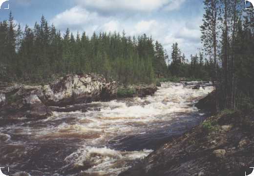
The trip up to this point had been a reasonably easy wilderness paddle. A
warm up for things to come. The next leg of the river was why we were really
here. In a 35 km portion of this river, it drops approximately 220 meters.
This results in 35 km of almost continuous rapids and waterfalls. This is
also the reason we encountered disbelief and discouragement whenever we
tried to find information on it. It was also the reason for the butterflies
in my stomach. Once committed to this river, from here on, there really was
no way out.
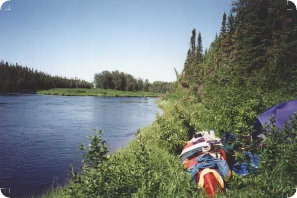
The mouth of the river was across a small bay from us. We set out on a
perfect summer day. Gentle breeze, sunshine, warm temperature. We saw
another potential campsite, on the south shore, just where the river leaves
the lake. In foul weather, this campsite would probably provide more shelter
from the wind than ours had.
From the very start this was a different river. Coming off the lake we could
feel the current pick up the canoe and even without paddling we moved along
quite quickly. The first rapids, very minor in nature, little more than
swifts really, came quickly. There was a moose below the rapids that Rob
captured on his camcorder. The moose didn't seem too concerned about our
presence. He watched us for a moment, and then slowly sauntered off into the
woods.
The river then slows, and moves gently through a very peaceful, pretty area.
About 10 or 11 km from the lake we encountered our first real set of rapids.
It's a long set that starts easily runnable and then slowly escalates in
difficulty. There's nothing major here, although our source of information
(Canoeing Ontario Rivers by Ron Reid and Janet Grand) indicated that
near the centre of this series of rapids, is a set that required tracking.
We ran through the entire series with no difficulty. Obviously they had different water levels than we did.
There was a high ridge running along the right hand side of the river which
could provide many reasonable camping opportunities. We camped on this ridge
where a small creek (Burn Creek) joins the Kesagami shortly after running
the rapids. There was a moose where the river met the creek, which again,
thought about us for a while before slowly wandering away.
The bugs were horrible that night so we ate dinner in our tent. While eating we
heard branches snap down at the creek, and assuming it was another moose, we
looked outside. A bear was wandering leisurely along the far side of the
creek (which was about 20 feet wide and less than 100 yards from us) and
showing great interest in crossing to investigate our canoe more closely.
After a few minutes he wandered away. Rob, playing camera man again,
captured it on film. Needless to say, we spent some time airing all traces
of food from our tent and carefully scrubbing our pots and pans.
The next day dawned sunny but quickly turned to cloud. As we left our
campsite another moose was at the river junction. Our first set of rapids
was visible from our camp, and we perched on a small island above them to
scout. With just a little bit of scraping, we paddled through. That's more
or less the story for that day. The rapids came frequently, and the calm in
between provided a good opportunity to either bail water or catch our
breath. Until our last set of the day, we ran everything we encountered. We
paused above each set, and Rob did his scouting from the canoe. If
necessary, lining along the shore was almost always possible. The rapids
were typically quite short, with calm water below each set. This was a
wonderful stretch of the river to gain confidence and hone one's skills.
Both of which will be in great demand later on.
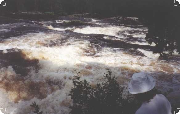
| Somewhere along the way it began to rain. It was raining when we encountered our first real test. The river split around an island, with quite serious chutes on either side. There was a set of rapids above the island that had to be run - then we had to perch on the tip of the island to access a rough portage trail through the island past the chutes. Then there was a series of rapids below the island which had to be run as well. This was certainly the most serious stretch of white water yet. We ran into a bit of difficulty landing onto the tip of the island and were heading for the right hand chute. Just when I had resigned myself to something unpleasant, Rob executed a rather unorthodox maneuver that managed to get us to shore (he jumped out of the canoe, and holding onto the canoe with one hand caught hold of some willows on shore with the other) . Once on the island we could see a potential portage along the right shore, which would have avoided having to run the first set of rapids and landing on the island. To take the shore portage you would have to leave the river a little further upstream, but it would enable you to bypass more of the rapids, and eliminate the rather tricky process of landing on the island. |
 |
Tired and wet we camped on the island. After making camp the sun came out on
a beautiful day.
The nature of the river was changing. This day was certainly more difficult
than the 'introductory' rapids yesterday. So far though, there was nothing
that would discourage anyone who's familiar with whitewater from doing this
trip. At this point Rob thought that it would only be a matter of time
before this became a well traveled route, and the warnings we'd received
were all over exaggerated.
Well, the next few days caused him to reconsider. The river got tougher.
There were 8 portages marked in the next days travel. They ranged from 25
meters to 200 meters. There was one obvious portage which was not included
on the map which made a total of 9 portages. We portaged all of these except
for two - one we ran and one (where we couldn't find the portage) we ran and
lined. There were also a number of lift-overs and tracks (11 - 12). We ran
most (all?) of these. We should mention that almost all of the portages were
difficult to find. The beginnings of the portages were marked only by blazes
on trees which were in many cases overgrown (hence the one we missed). We
camped on the unmarked portage.
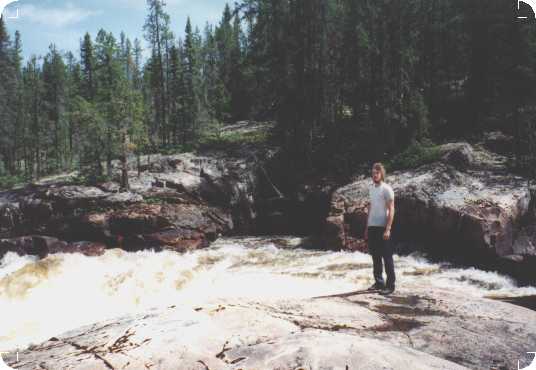
This is beautiful country.
All along this river the rocks were very slippery when wet! We did many a
slip/slide today while lining/tracking. It was frustrating (and scary)
when you think you have a firm footing and you don't.
The next day we woke to sunshine!! It was a tough day. We traveled only 4
km - approximately 2 of which were portage. The Bog Walk was 1.5 km long,
but easy to follow (fortunately). The next 450 km portage was a loss (or
should I say we got lost). We ran the rapids in between (2 of which were
marked 'track' and 'lift over').
We were so busy looking for a set of rapids marked 'line' that we surprised
ourselves at the top of Whaleback Falls and had a horrible time following
the portage around it. The trail seemed very obvious at the start so we didn't
scout it first. We simply set off with Rob carrying the canoe and me
carrying one pack. We ended up 'bushwhacking' with all our gear. It was not
pleasant.
Anyway, four hours of travel that day brought us to a nice campsite on an
'almost island' below the falls. There was a large rock below the falls,
which from a certain angle, actually looked like a Whale's back.
We woke to a beautiful day and decided to stay here for a rest day. Believe
it or not - there we were in the middle of nowhere, and there was broken
glass at the campsite (Rob cut his foot). Is there no place that man's trash
hasn't gone?
We had a lovely day.. sat in the sun, ate lots, even jumped into the narrows
beside our 'almost island' and let the current whisk us downstream.
As much as we wanted a rest day, by the end of the day we were ready to go
on - curious and eager to see what was around that next bend.
We set out on another nice day. Just below our campsite there was a widening
(and calming) of the river - we saw a cabin up in the woods to the left.
That could only mean that it was possible to fly in there, also, it could
have been a good place to fish.
Well, the next day was our toughest yet. Even Rob was willing to admit that
this probably wasn't going to become a standard canoe route - and maybe
everything people told us about it was true. We traveled 5 km in 5 hours.
Six rapids were marked track or lift over - we found that we had to track or
lift over most of them. We attempted to line and then run one set (accessing
them in the middle of the rapid) and we swamped (swim #1 ever for me). There
are 8 marked portages in today's portion, ranging from about 100 to 450
meters in length - again most were shorter than the distance marked. We
missed one portage (as I mentioned previously - the blazes are often
difficult to see) and we tried to run the top of the rapids, and swamped
(swim #2 for me). We recovered the canoe and lined the rest of the way. The
river was teaching me some humility. I had been beginning to feel a little
over-confident - today I was put in my place.
We camped on the portage trail by Tombstone rapids.
The fun of the rapids had worn off now. I was very glad that we only had
about 3 km to go before we were out of the rapids.
In those remaining 3 km we had 3 portages left to do - we portaged them all.
Also 5 lift-over/tracks - we found all of them to be necessary as well.
There were a few sets of runnable rapids in between. We followed the rules
today (much to Rob's chagrin) and did more or less as our map indicated. As
I said - we (I at least) learned humility the previous day. Rob was still
willing to try running things that looked more and more terrifying to me.
4) End of Rapids to James Bay (days 14 - 15)
The river changed again after the 'last portage'. There were no more rapids.
It was wider, but still swift flowing. Portions of it were fairly shallow.
We didn't have to wade, but with lower water? Let's just say we wouldn't
want to be doing this with 6 inches less water!
The wind was against us for most of the day so we had to work!
The river banks were weird here. They appeared to be clay, and frequently
they just sort of slumped into the river bringing down whatever forest
happened to be growing on them.
As much as at first, I had enjoyed camping to the sound of rapids, it was a nice
change to camp beside a peacefully flowing river. Also, for
the first time in many days, there are deciduous trees by the river - and we
could hear the pleasant sound of the wind in the leaves. I never realized
that I'd been missing it.
The next day gave us blue sky and NO rain at all! We made it down to James
Bay. We met the incoming tide about 4 km up river. I had read that this
could happen, but I had never experienced it. The combination of an incoming
tide and the north wind slowed our progress to almost nil. We stopped for a
while, waiting for the tide to change, but eventually we got bored and moved
on. We only had 2 - 3 km to go to where we planned to camp but it seemed to
take forever! It was a really nasty, slow paddle.
Our guide (Canoeing Ontario's Rivers) mentioned a McMaster University Field
camp a couple of km up from the mouth of the river as a possible camp site.
We checked it out but after days in the almost pristine wilderness we were
discouraged by the garbage around the site. We paddled further down river
and found a camping spot in a small clearing in the willows about 1 km from
the Bay.
It had been a long day. We paddled for about 7 hours with 1 hour off trying
to figure out what to do about the tide, as well as some time off for lunch.
We saw a couple of otters...some Canada Geese (+goslings).
We camped pretty close to high tide, and watched the river retreat from the
bank as the tide went out.
5) James Bay/Moose River (days 16-17)
We started out on the James Bay portion of our journey at about 8:30 am and
caught the outgoing tide. We made great progress until we ran out of water.
We knew the tidal flats were wide, but on the one map we were missing, the
tidal flats went out around an island - a big one - far from shore - which
we ended up going around! We ended up way, way out from shore - then a north
wind came up just as we were rounding the island and we sailed/paddled
quickly back to shore, bailing water as the waves washed in. Sky did not
enjoy this day.
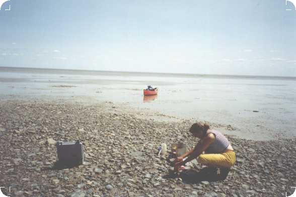
By the way, when we were high and dry before going around the island we made
pancakes on the tidal flats.
We finally got to Nettish Point at about 6:00. What a LONG day! There was a
nice wide sand/stone beach, with lots of camping possibilities just back
from the beach. Luckily, we got to the point at high tide. When the tide goes out,
solid (dry) land is a LONG way away from the water. If you are crossing the
Bay, and want to land here, time yourself to come in at high tide or you'll
have a long portage across the mud flats. Also, the point may be more
difficult to find from a few kilometers out. If you miss the point you're
soon into the Partridge river delta and there are virtually no camping
possibilities there.
Our information indicated that there was a Lands & Forests hut of some sort
near which we could camp. We found that it looked more like and Indian
hunt/fish base (more garbage) - we camped far away.
We ran out of fresh water during the day, so we hiked a few hundred yards
inland to a swamp/lake where we got lots of water, and for the first time on
this trip, we boiled our drinking water.
Who in the world besides Rob could go beach combing on a deserted stretch of
James Bay and find a beer? Can you believe it!!! (Boy was it good!)
Our approach the next day was to catch the incoming tide to take as much
advantage of the high tide as possible. We got up at 4:30 am, the tide was
still way out. We got up again at 5:00 and found that the tide had come in a
lot. We packed up and were on the water by 5:30. We hoped to cross the tidal
flats of the Partridge river delta and get to the Moose River before the
tide went back out (about a 21 or 22 km paddle). The tide tables indicated
that high tide was 6:50 so we had an hour and 20 minutes of incoming tide,
before it began to go out.
The water was very, very, still. Paddling very steadily, we reached the
Moose River at about 9:15. Behind us the tidal flats were beginning to
appear. Another hour and we'd have been parked high and dry again! It
was
really quite eerie to see them appear out of the water.
The tide continued to go out so we had a long, slow paddle against both the
outgoing tide and the current of the Moose River. If possible, try for an
incoming tide and/or a north wind. Otherwise this is a very unpleasant
paddle. A north wind picked up eventually and then we sailed a bit. We
reached Tide Water Provincial Park at about 2:30 or 3:00. It was a LONG,
hard day (over 9
hours of paddling). The trip is virtually over when you get to the Moose
River, and this portion is just hard work. The Moose River breaks into a
number of channels as you go upstream. Try for one of the right hand (west
side) channels. That way as you paddle you begin to see Moosonee in the
distance and you have a visual goal.
We went into Moosonee for some steaks, fresh potatoes and beer. I went into
a hotel and 'begged' a shower. They said 'no problem'. It's the best shower
I've ever had (in spite of the mould growing in the bathroom). They weren't
even going to charge us for the shower but we insisted. I guess it's also
the most expensive shower we ever had.
Summary
Was it a good trip? Yes. Worth doing? Without a doubt.
The number of times I thought with less than pleasure 'I'm never coming back
to this God forsaken wilderness' were far outweighed by the number of times I
thought, with some degree of sadness, 'Sigh... I will probably never be back
here again...'. So the trip was definitely more good than bad.
The Upper Kesagami Lake to Kesagami Lake portion of the river was mildly
interesting, and a good way to warm up those old paddling muscles. The
first few days of paddling are always rather special - the silence, the
peace. Otherwise, it was 'just a river'. Nothing too spectacular there. With higher
water some of the rapids may have been fun.
Kesagami Lake was a worthwhile fishing stop. This is where most people fly
in to start the rest of the river. It's difficult to enjoy and relax on the
lake though, with the anticipation of what lies ahead.
The Kesagami River rapid section was in some ways easier than what I
expected - and in other ways tougher. There were more runnable rapids than
expected, and nothing was impossible to either run, lift over, track or
portage. What was tougher was the reality of the portages - unpack the canoe
- portage - go XX meters - go back get the rest of the gear - portage -
repack the canoe - and sometimes you could already see the next portage ahead of
you before you're even in the water. Portage trails were very badly marked
and often difficult not only to find but to follow. There was certainly no question of
getting bored on this part of the river.
The bottom of the river from the last portage to the Bay was a pleasant
break from all the hard work you've been doing in the previous days. As much
fun as the rapids were, it was nice to just paddle and look at the
scenery for a change. In two days you're down at the Bay.
James Bay/Moose River. Well, the Bay is obviously passable. You wouldn't
want to be doing this in foul weather, and I should mention that all of the
local people we talked to (Ministry of Natural Resources, outfitters, etc.)
advise you not to paddle the Bay. Even with the tide on your side, it's just
a long (and after a little while) boring, haul. The prevailing winds are
north westerly. It could be a VERY long haul against a westerly wind. The
trip up the Moose River is a necessary evil ... the end of the trip is so
close that these last kilometers seem to take forever to do. We should
mention that the alternative to paddling James Bay is either to have a float
plane pick you up in Hanna Bay (where the Kesagami & Harricanaw Rivers meet
James Bay) - an expensive option - or, have a freighter canoe pick you up
there and take you to Moosoneee. There seems to be some sort of mysterious
paddlers pride that requires a paddler to cross the Bay. Personally I don't
understand it, but Rob obviously does.
It was a 17 day trip with two rest days, so the whole thing is possible in
15 days. Weather permitting, stretch it out, take more time. One last word
about the weather. This may have been the toughest aspect of the trip for
me. Being wet and cold day after day really wore me down. The same river could be
much different with warmth and sunshine - and I do believe (really) that the
weather can be quite reasonable up here (take for example the hot dry spell
that preceded our trip). It's the luck of the draw I guess. Historically our
canoe trips seem marked by cool, wet weather. Except for some nice days on
the second half of the trip, this was no exception.
Sky Bicevskis
Topo Maps (1:50,000)
42 H/9 North Burntbush Lake
42 H/16 Lawagamau Lake
42 I/1 Ministik Lake
42 I/8 Kesagami Lake
42 I/9 Glaister Lake
42 I/16 Marberg Creek
32 L/13 Atik River
32 M/4 Francis Island
42 P/8 Ship Sands Island
42 P/7 Moosonee